


PCR-GLOBWB 1.0
 PCRaster Global Water Balance: version 1.0
Key documentation: Van Beek and Bierkens (2009) (model concepts) Van Beek (2008) (Preparation of meteorological forcing)
Van Beek et al. (2011) (model validation)
Download:
The water balance model (no routing, no water use) is available from the following public repository:
https://github.com/UU-Hydro/PCR-GLOBWB_model
Description:
PCR-GLOBWB is a large-scale hydrological model intended for global to regional studies and developed at the Department of Physical Geography, Utrecht University (Netherlands). PCR-GLOBWB provides a grid-based representation of terrestrial hydrology with a typical spatial resolution of less than 50×50 km (currently 0.5° globally) on a daily basis. Similar to other large-scale hydrological models, PCR-GLOBWB is essentially a leaky bucket type of model [1] applied on a cell-by-cell basis. For each grid cell, PCR-GLOBWB uses process-based equations to compute moisture storage in two vertically stacked soil layers as well as the water exchange between the soil and the atmosphere and the underlying groundwater reservoir. Exchange to the atmosphere comprises precipitation, evapotranspiration and snow accumulation and melt, which are all modified by the presence of the canopy and snow cover. The exchange with the underlying groundwater reservoir comprises deep percolation and capillary rise and vertical fluxes are shown in Figure 1.
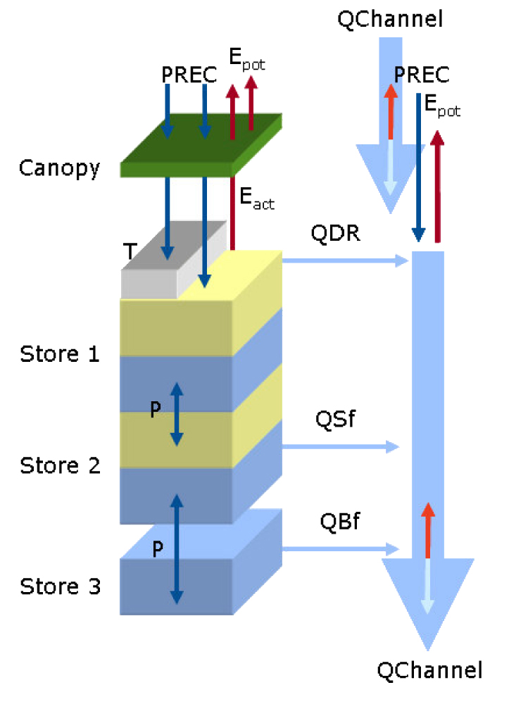 Figure 1: Model concept of PCR-GLOBWB. Left: layers describing the soil hydrology including the canopy, snow cover, soil layers 1 & 2 and the groundwater reservoir 3 as well as the exchange of moisture between them; right: specific runoff components and the direct gains/losses over the drainage network returning discharge along the channel when routed.
Sub-grid variability is taken into account as follows:
- fraction of cell covered with short and tall vegetation;
- fraction covered with freshwater, being either a river, lake or reservoir;
- fraction glaciers;
- sub-grid elevation distribution determining the accumulation and melt rate of snow and ice as well as fraction of the river plain flooded (optional);
- soil type distribution and its effect on soil hydrological properties;
- distribution of water-holding capacity of the soil resulting in variable saturation excess overland flow [Improved Arno Scheme, 2] as a result of variations in soil depth, effective porosity and elevation distribution.
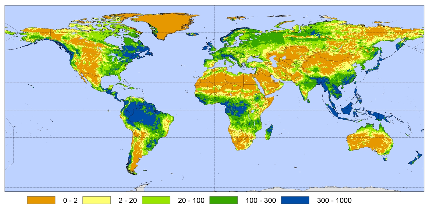 Figure 2: Mean annual groundwater recharge in millimetre/year as simulated with PCR-GLOBWB (Wada et al., 2010)
Saturation-excess overland flow is one of the three specific runoff components depicted in Figure 1. Also included are interflow along hillslopes and baseflow from the groundwater reservoir. River discharge is calculated by accumulating and routing specific runoff along the drainage network by means of the kinematic wave approximation for rivers and a stage-discharge relationship for lakes using variable time-stepping (Figure 3). Standard, these flow domains are evaluated for floodplains and lakes with a static extent. Optionally, PCR-GLOBWB allows to evaluate the routing scheme with lakes and floodplains of variable extent, thus simulating flooding and flood wave attenuation and for the inclusion of a prognostic reservoir scheme akin to that of Haddeland et al. [3]. Additionally, there is the option to include a surface water energy scheme to simulate water temperature and ice extent (Figure 4).
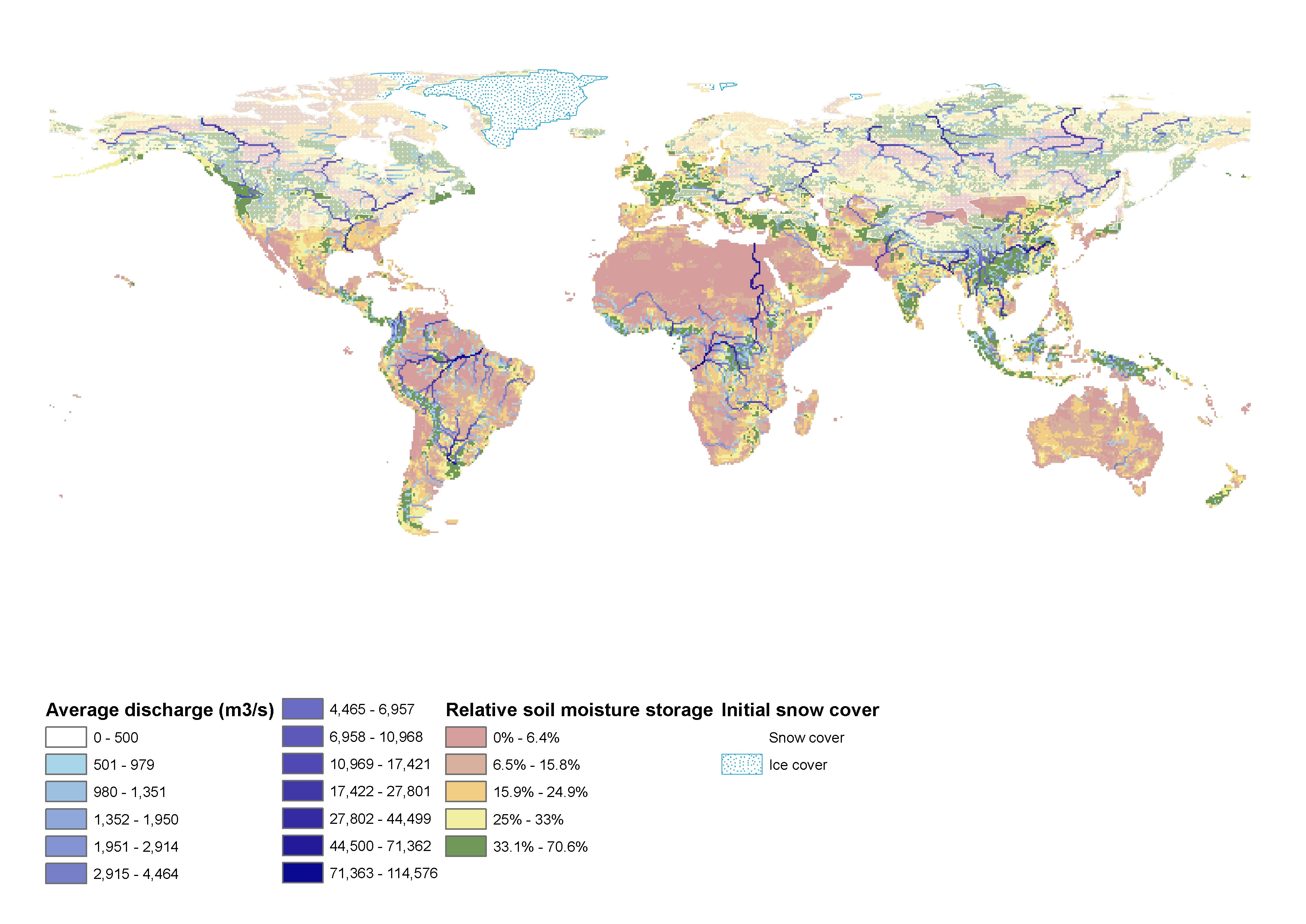 Figure 3: Composite image of river discharge, relative moisture content and winter snow cover
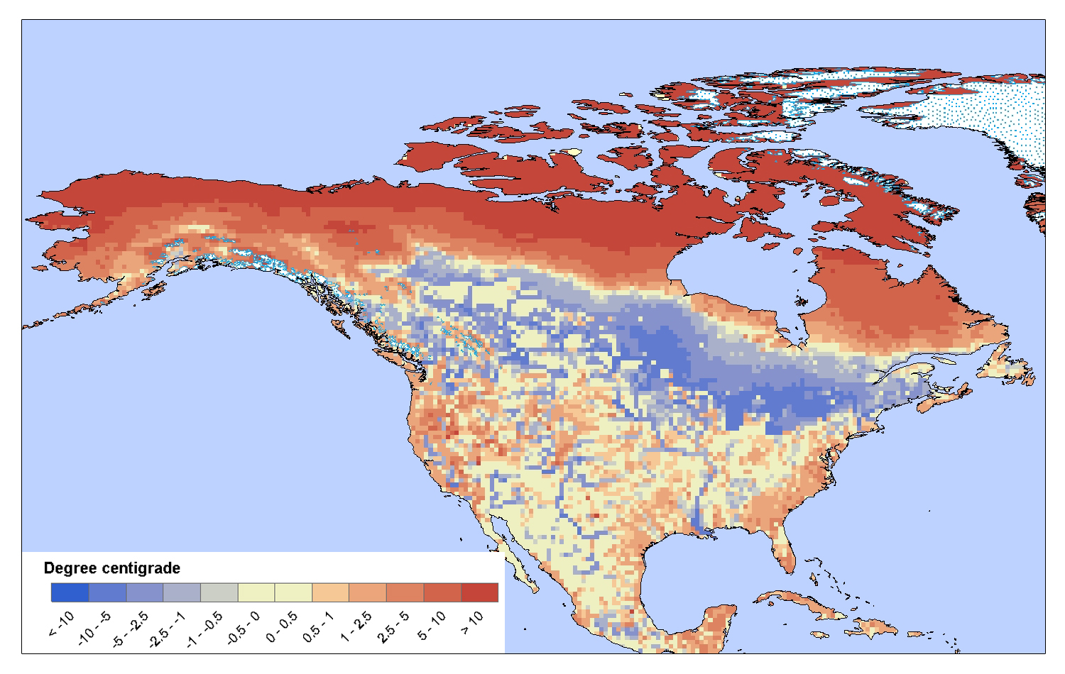 Figure 4: Mean difference between surface water temperature and overlying air temperature over North America in April. Negative values denote colder water temperatures. Note the transport of cold water southward by the Mississippi and the Rio Grande as well as the inertia in temperature over the Great Lakes.
PCR-GLOBWB is partly coded in PCRaster and partly in PCRaster-Python. Scripts allow for a fairly easy conversion of the existing parameterization at the global scale to individual continents or basins at the original 0.5° resolution to finer scales (typically grid size of 1-10 km). On the global scale, PCR-GLOBWB is used in seasonal prediction, to quantify the hydrological effects of climate variability and climate change change, to compare changes in terrestrial water storage with observed anomalies in the Earth’s gravity field and to relate demand to water availability in the context of water scarcity. On the regional scale PCR-GLOBWB is used to study the influence of wetland hydrology on methane emissions for the circum-arctic, to study water availabilty and adaptation strategies, and to quantify sediment, carbon and nutrient fluxes for a range of catchments including the Rhine, Mississippi, Mekong and Usa.
References
- Bergström, S., 1976, The HBV Model. In: Computer models of watershed hydrology (V.P. Singh ed.), Colorado, Water Resources Publications, 443-476.
- Hagemann, S. and L.D. Gates (2003), Improving a subgrid runoff parameterization scheme for climate models by the use of high resolution data derived from satellite observations, Climate Dynamics 21, 349–359.
- Haddeland, I., T. Skaugen and D.P. Lettenmaier (2006), Anthropogenic impacts on continental surface water fluxes, Geophysical Research Letters 33, L08406, doi:10.1029/2006GL026047, 2006b.